
Forecasting the future of cities, neighborhood by neighborhood
Introducing Oxford Economics’ new granular urban model—our first Quantitative Spatial Equilibrium model—designed to forecast and visualize how cities evolve at neighborhood scale.
For decades, economic forecasting at the national, regional, and city level has provided a robust foundation for decision-making. For many applications, this level of analysis remains entirely appropriate, offering a clear and consistent view of economic trends and performance.
But a single, city-level average can hide just as much as it reveals. Take a city’s headline growth figure: while robust on the surface, it can mask a thriving downtown core alongside a struggling suburb—obscuring exactly what local leaders and business need to see. Richer data and advances in modeling now make it possible to see past the average. By looking within cities, rather than treating them as single entities, organizations can unlock a new set of insights to support more targeted, location-specific decisions and strategy.
At Oxford Economics, we are developing ANIMA, a new generation urban forecasting model designed to capture this additional detail: granular, spatial forecasts that operate across thousands of small areas within a city. It is built for the decisionmakers who operate below the city level—from consumer-facing businesses choosing where to locate and invest, to real estate investors and developers deciding where to build, to policymakers shaping how neighborhoods evolve.
ANIMA is our first Quantitative Spatial Equilibrium model, and it can be run for any major US metropolitan area. It builds on our existing city and regional models, breaking down their results to a much more granular level. To give a sense of the scale involved, in New York alone, the model decomposes the metropolitan area into more than 17,000 hexagonal cells, each less than 1 km across, and produces a forecast for each one out to 2050 across a detailed range of economic indicators.
Why granularity matters
Cities are not homogeneous. Even within a strong overall urban economy, neighboring areas can follow very different trajectories in terms of employment, income, population change, and real estate demand.
Figure 1, a map produced using ANIMA, shows income differences in the center of New York: 3D vertical bars indicate employment intensity, while the colors represent personal income across each 1 km hexagon.
Figure 1: Mapping employment and disposable income in 2024 at the 1 km neighborhood level in New York City
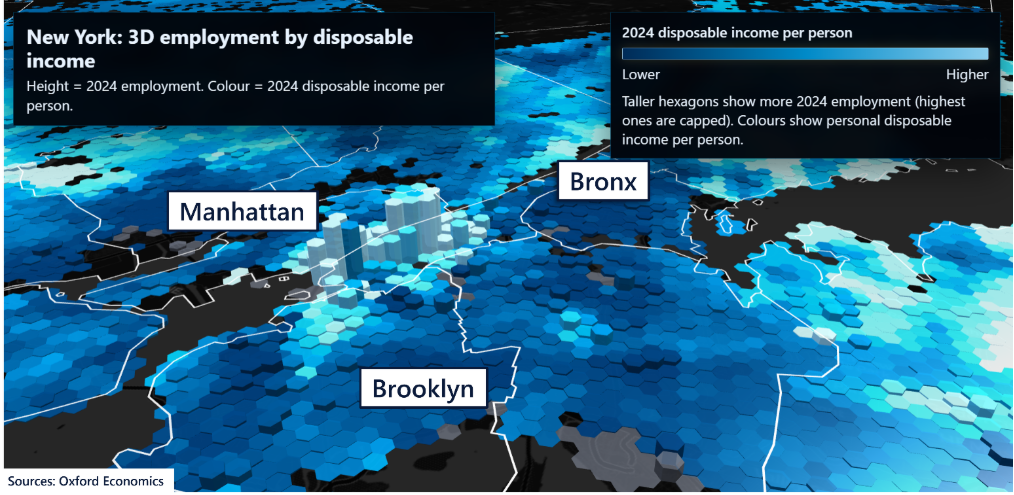
Even this single snapshot tells an interesting story. Many lower-income households in the Bronx live right at the doorstep of the highest-paying jobs in Manhattan, while other parts of Brooklyn have already emerged as high-income neighborhoods in their own right. Evidently, the economic realities and futures of communities living within the same metropolitan area, often within a few hundred meters of each other, are very different.
And understanding these differences is becoming increasingly important: investment decisions, site selection, infrastructure planning, and policy interventions are often made at a much more local level than the city as a whole. Granular forecasting provides a way to align economic insights with the scale at which decisions are actually taken and where businesses actually operate.
A new way to model cities
ANIMA builds on established city-level forecasting by modeling how different parts of a city interact and evolve together. It draws on the growing Quantitative Spatial Equilibrium literature in urban economics and provides a rigorous way to link where firms locate, where households live, and how wages, rents, accessibility, and real estate markets adjust to one another over time.
At its core, this framework captures how:
- Households choose where to live based on income, housing costs, and accessibility
- Firms decide where to locate based on productivity, land costs, and access to labor
- Real estate markets respond to demand across residential and commercial space
These elements are closely interconnected. Changes in one part of the system—such as job growth in a specific area—feed through to others, influencing population movements, housing demand, and local prices.
Modeling a city at this resolution requires bringing together rich, innovative datasets. For example, ANIMA draws on granular buildings and building heights data, detailed real estate data, and hexagon-to-hexagon multimodal journey times to capture how long it takes to travel between any two locations, across every mode of transport. Together, these layers let ANIMA represent accessibility, density, and the built environment at neighborhood scale, rather than as city-wide averages.
The framework also allows us to explicitly incorporate the impact of infrastructure and policy changes. For example, new transport connections, housing supply interventions, or shifts in land-use policy can be introduced into the model, enabling us to assess how they would reshape local economic outcomes over time.
A step-change in urban forecasting
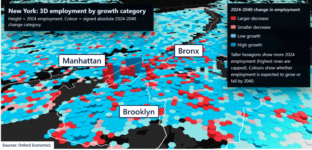
By combining detailed data with a spatial modeling framework, ANIMA complements our existing city-level analysis, adding a new dimension of insight where it is most valuable. Figure 2 shows our forecast for employment change by 2040: we forecast more jobs in the blue hexagons and fewer jobs in the red ones. The model considers a range of factors—including past employment and productivity growth, real estate prices, and available floorspace—to produce this forecast.
The results reveal remarkable spatial variation, with areas of declining employment sometimes located directly next to areas of growth. In Manhattan, total employment continues to rise, but land availability and real estate profitability concentrate this growth in already dense areas, leading to even greater spatial specialization. Employment is also set to grow across Brooklyn and the Bronx, albeit from a relatively low base, with declines limited to smaller pockets.
Figure 2: Mapping employment growth at the 1km neighborhood level in New York City
What we are building towards
Our ambition for ANIMA is to develop a comprehensive, forward-looking view of major US cities at a highly granular level. Across thousands of locations, the model will forecast population, employment by sector, productivity, GDP, personal income, residential real estate prices, and housing affordability.
This will allow clients to:
- Track baseline trends across neighborhoods
- Assess the local impact of economic, infrastructure, and policy changes
- Identify emerging opportunities and risks with greater precision
In doing so, we aim to extend the value of forecasting from understanding overall urban performance to supporting decisions at the level where they are made. ANIMA is that next step, and we are excited to see how this new generation of urban forecasting can help clients better understand the future of cities.
Request a free trial
Complete the form and we will contact you to set up your free trial. Please note that trials are only available for qualified users. We are committed to protecting your right to privacy and ensuring the privacy and security of your personal information. We will not share your personal information with other individuals or organisations without your permission.